|
Click here for any release note(s) that may apply to this release.
The Catalog Archive Server (CAS) provides access to the
database that contains the object catalogs and
related data from the Sloan Digital Sky Survey-III (SDSS-III). It is a
companion to the Science Archive Server (SAS),
which allows users to download raw (FITS) images and spectra from the survey.
The SkyServer provides the Web interface to the CAS database. This page
describes the database organization and structure.
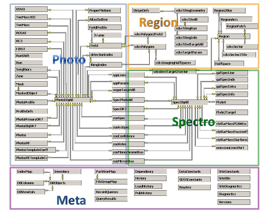
Data Organization
The SDSS Catalog Data Model
The SDSS catalog data is stored in a commercial relational database management
system (DBMS) - Microsoft's SQL Server. The data is therefore organized
in several 2-dimensional tables. The tables and their relationships to each
other are referred to as the schema in database jargon. The Schema link in the menubar
above takes you to the Schema page where you can browse the database schema.
There are 3 different types of data in the tables - imaging data
is in the photo group of tables, spectroscopic and tiling data is
in the spectro tables, and other data such as documentation or other
information about the photo and spectro data, i.e. metadata, is in the
meta tables. Some tables are also created specifically for speed or
convenience, for example the SpecPhotoAll table, which contains a pre-computed
JOIN of relevant fields in the PhotoObjAll and SpecObjAll tables.
The important tables are described below, along with the views that are
currently defined on each table. A view is a subset of the corresponding
table that can be used instead of the table - in other words it is a
virtual table. A view is usually faster than using the base table,
since it only loads a subset of the objects, but more importantly, the views
we have defined on the tables select only the objects that are important for
science, and they filter out non-science objects such as sky, QA or defective
observations. As such, even though we list the base tables for
completeness below, in the vast majority of the cases, you should use the
views defined on the tables instead of the tables themselves, e.g. use
the PhotoObj and SpecObj views for science instead of the PhotoObjAll and
SpecObjAll tables.
Imaging (Photo) Data Tables 
The important tables and views are described below. For each table, the views
and indices are defined on that table are described in brief. For more
information, please see the Table Descriptions
help page and the Schema Browser.
- PhotoObjAll - By far the largest table in the database, PhotoObjAll contains
the 100+ parameters for each imaging (photo) object. For most of these parameters, there are
actually 5 rows each, one for each wavelength band. This table includes data on all photo
objects, not just science objects, hence the name PhotoObjAll. The view of this
table that includes only science objects and excludes sky and other unknown objects is
the PhotoObj view. The PhotoObjAll table is there for completeness, but science queries
are usually done on the PhotoObj view.
PhotoObjAll Views:
| View Name | Contents | Description |
| PhotoFamily |
These are in PhotoObj, but neither PhotoPrimary or Photosecondary. | These objects are generated if they are neither primary nor secondary survey objects but a composite object that has been deblended or the part of an object that has been deblended wrongfully (like the spiral arms of a galaxy). These objects are kept to track how the deblender is working. It inherits all members of the PhotoObj class. |
| PhotoObj |
All primary and secondary objects in the PhotoObjAll table, which contains all the attributes of each photometric (image) object. | It selects PhotoObj with mode=1 or 2. |
| PhotoPrimary |
These objects are the primary survey objects. | Each physical object on the sky has only one primary object associated with it. Upon subsequent observations secondary objects are generated. Since the survey stripes overlap, there will be secondary objects for over 10% of all primary objects, and in the southern stripes there will be a multitude of secondary objects for each primary (i.e. reobservations). |
| PhotoSecondary |
Secondary objects are reobservations of the same primary object. | |
| PhotoTag |
The most popular columns from PhotoObjAll. | This view contains the most popular columns from the PhotoObjAll table, and is intended to enable faster queries if they only request these columns by making use of the cache. Performance is also enhanced by an index covering the columns in this view in the base table (PhotoObjAll). |
PhotoObjAll Indices:
| Index Type | Key or Field List |
| primary key | objID |
| foreign key | Field(fieldID) |
| covering index | mode, cy, cx, cz, htmID, type, flags, ra, dec, u, g, r, i, z |
| covering index | htmID, cx, cy, cz, type, mode, flags, ra, dec, u, g, r, i, z |
| covering index | htmID, run, camcol, field, rerun, type, mode, flags, cx, cy, cz, g, r |
| covering index | field, run, rerun, camcol, type, mode, flags, rowc, colc, ra, dec, u, g, r, i, z |
| covering index | fieldID, objID, ra, dec, r, type, flags |
| covering index | SpecObjID, cx, cy, cz, mode, type, flags, ra, dec, u, g, r, i, z |
| covering index | cx, cy, cz, htmID, mode, type, flags, ra, dec, u, g, r, i, z |
| covering index | run, mode, type, flags, u, g, r, i, z, Err_u, Err_g, Err_r, Err_i, Err_z |
| covering index | run, camcol, rerun, type, mode, flags, ra, dec, fieldID, field, u, g, r, i, z |
| covering index | run, camcol, field, mode, parentID, q_r, q_g, u_r, u_g, fiberMag_u, fiberMag_g, fiberMag_r, fiberMag_i, fiberMag_z |
| covering index | run, camcol, type, mode, cx, cy, cz |
| covering index | ra, [dec], type, mode, flags, u, g, r, i, z, psfMag_u, psfMag_g, psfMag_r, psfMag_i, psfMag_z |
| covering index | phototag |
| covering index | parentid, mode, type |
- Field - This table contains all the measured
parameters of each imaging field
 , along
with relevant summary statistics, and astrometric and photometric information. , along
with relevant summary statistics, and astrometric and photometric information.
Field Indices:
| Index Type | Key or Field List |
| primary key | fieldID |
| covering index | field, camcol, run, rerun |
| covering index | run, camcol, field, rerun |
- PhotoProfile - This table contains the light
profiles of SDSS photo objects.
PhotoProfile Indices:
| Index Type | Key or Field List |
| primary key | objID, bin, band |
| foreign key | PhotoObjAll(objID) |
- FieldProfile - This table contains the light
profiles of SDSS field objects.
FieldProfile Indices:
| Index Type | Key or Field List |
| primary key | fieldID, bin, band |
| foreign key | Field(fieldID) |
- Neighbors - SDSS objects within 0.5 arcmins and
their match parameters are stored here. Make sure to filter out unwanted
PhotoObj, like secondaries.
Neighbors Indices:
| Index Type | Key or Field List |
| primary key | objID, NeighborObjID |
| foreign key | PhotoObjAll(objID) |
- First,
RC3, Rosat, TwoMASS, TwoMASSXSC and Usno - These tables contain matches between the FIRST, RC3, ROSAT, 2MASS, 2MASSXSC (2MASS Extended Source Catalog) and USNO survey objects respectively and SDSS.
Spectro/Tiling/GalSpec/SPP Data Tables
The important spectro, tiling, galSpec and spp (Stellar Parameter
Pipeline) data tables are described here. The tiling table names are
prefixed by "sdss" to distinguish them from tiling tables for BOSS
(Baryon Oscillation Spectroscopic Survey) data in the future. For more
information, please see the Table
Descriptions help page and the Schema
Browser.
- PlateX - This table contains data as exported (the
X is for exported) from a given plate used for spectroscopic observations.
Each plate has 640 observed spectra and hence 640 corresponding entries in
SpecObjAll.
PlateX Indices:
| Index Type | Key or Field List |
| primary key | plateID |
| covering index | htmID, ra, dec, cx, cy, cz |
- SpecObjAll - This is a base table containing
ALL the spectroscopic information, including a lot of duplicate and bad
data. Use the SpecObj view instead (see below), which has the data
properly filtered for cleanliness.
SpecObjAll Views:
| View Name | Contents | Description |
| SpecObj |
A view of Spectro objects that just has the clean spectra. | The view excludes QA and Sky and duplicates. Use this as the main way to access the spectro objects. |
SpecObjAll Indices:
| Index Type | Key or Field List |
| primary key | specObjID |
| foreign key | PlateX(plateID) |
| covering index | htmID, ra, dec, cx, cy, cz, sciencePrimary |
| covering index | BestObjID, sourceType, sciencePrimary, class, htmID, ra, dec, plate, mjd, fiberid, z, zErr |
| covering index | class, zWarning, z, sciencePrimary, plateId, bestObjID, targetObjId, htmID, ra, dec |
| covering index | targetObjID, sourceType, sciencePrimary, class, htmID, ra, dec |
| covering index | ra, [dec], class, plate, tile, z, zErr, sciencePrimary, plateID, bestObjID |
| covering index | fluxObjID |
- SpecPhotoAll - The combined spectro and photo
parameters of an object in SpecObjAll. This is a precomputed join between the
PhotoObjAll and SpecObjAll tables. The photo attibutes included cover about
the same as in the PhotoTag view. The table also includes certain
attributes from the Tile table.
SpecPhotoAll Views:
| View Name | Contents | Description |
| SpecPhoto |
A view of joined Spectro and Photo objects that have the clean spectra. | The view includes only those pairs where the SpecObj is a sciencePrimary, and the BEST PhotoObj is a PRIMARY (mode=1). |
SpecPhotoAll Indices:
| Index Type | Key or Field List |
| primary key | specObjID |
| foreign key | SpecObjAll(specObjID) |
| covering index | objID, sciencePrimary, class, z, targetObjid |
| covering index | targetObjID, sciencePrimary, class, z, objid |
- sdssTileAll - Contains information about individual
tiles on the sky.
sdssTileAll Views:
| View Name | Contents | Description |
| sdssTile |
A view of sdssTileAll that have untiled=0 | The view excludes those sdssTiles that have been untiled. |
sdssTileAll Indices:
| Index Type | Key or Field List |
| primary key | tile |
| foreign key | sdssTilingRun(tileRun) |
| covering unique index | tileRun, tile |
| covering index | htmID, racen, deccen, cx, cy, cz |
- sdssTiledTargetAll - This table stores information that
keeps track of why a target
was assigned to a tile.
sdssTiledTargetAll Views:- None found
sdssTiledTargetAll Indices:
| Index Type | Key or Field List |
| primary key | targetID |
| covering index | htmID, ra, dec, cx, cy, cz |
- sdssTilingGeometry - This table contains geometrical
information about tiling regions, including tiling boundaries. The
TileBoundary view serves up the boundaries.
sdssTilingGeometry Views:
| View Name | Contents | Description |
| sdssTilingBoundary |
A view of sdssTilingGeometry objects that have isMask = 0 | The view excludes those sdssTilingGeometry objects that have isMask = 1. See also sdssTilingMask. |
| sdssTilingMask |
A view of sdssTilingGeometry objects that have isMask = 1 | The view excludes those sdssTilingGeometry objects that have isMask = 0. See also sdssTilingBoundary. |
sdssTilingGeometry Indices:
| Index Type | Key or Field List |
| primary key | tilingGeometryID |
| foreign key | sdssTilingRun(tileRun) |
- sdssTilingRun - Contains basic information about each
run of the tiling software.
- sdssTilingInfo - Contains information on what happened
to a Target in a run of tiling software.
- galSpecExtra,
galSpecIndx,
galSpecInfo and
galSpecLine-
These tables contain the estimated physical parameters,
the spectral index measurements, general information
about the spectroscopic analysis and the emission line
measurements from the MPA-JHU spectroscopic catalog.
galSpecExtra Indices:
| Index Type | Key or Field List |
| primary key | specObjID |
galSpecIndx Indices:No indices defined on this table
galSpecInfo Indices:
| Index Type | Key or Field List |
| primary key | specObjID |
galSpecLine Indices:
| Index Type | Key or Field List |
| primary key | specObjID |
- sppLines
and sppParams-
These tables contain the line and paramater measurements
from the Stellar Parameter Pipeline.
sppLines Indices:
| Index Type | Key or Field List |
| primary key | specObjID |
sppParams Indices:
| Index Type | Key or Field List |
| primary key | specObjID |
Galaxy Zoo Tables
There are the results of galaxy classification from the Galaxy Zoo site:
- zooConfidence - Measures of classification confidence from Galaxy Zoo.
- zooMirrorBias - Results from the bias study using mirrored images from Galaxy Zoo.
- zooMonochromeBias - Results from the bias study that introduced monochrome images in Galaxy Zoo.
- zooNoSpec - Morphology classifications of galaxies without spectra from Galaxy Zoo.
- zooSpec - Morphological classifications of spectroscopic galaxies from Galaxy Zoo.
- zooVotes - Vote breakdown in Galaxy Zoo results.
BOSS Galaxy Product Tables
There are a few new tables for derived data products from the Baryon Oscillation Spectroscopic
Survey. They each have a primary key index on specobjid.
- emissionLinesPort - Emission line kinematics results for BOSS galaxies using GANDALF.
- stellarMassPassivePort - Estimated stellar masses for BOSS galaxies using photometric method, assuming passive model.
- stellarMassStarformingPort - Estimated stellar masses for BOSS galaxies using photometric method, assuming a star-forming model.
- stellarMassPCAWiscBC03 and stellarMassPCAWiscM11
- Estimated stellar masses for BOSS galaxies using PCA technique.
Metadata and Other Tables
- DBObjects - An auto-generated documentation table
that contains a description of every object (table, view, function, stored
procedure) in the database.
- DBViewCols - An auto-generated table containing a
description of every column in every table in the database.
- DBColumns - An auto-generated table containing a
description of every column in every view in the database.
The Hierarchical Triangular Mesh (HTM)
We have built a spatial indexing scheme called the
Hierarchical Triangular Mesh (HTM) that spatially decomposes the region of the sky
that is covered by the SDSS data and enables much faster spatial searches of the data
by coordinate cuts.
Database Indices
In addition to the HTM, which is an overall indexing scheme for multidimensional spatial
data, the DBMS itself has the capability to define indices for fast searches on each table.
We have defined indices on all the major tables.
An index is a tree representation of a subset of the columns in a table that enables much
faster searches of the table (compared to sequential scans of the table data) when
constraints involving those columns are included in the query. All tables have an index
on their primary key (unique row identifier), but the larger tables have indexes
in addition to the primary key index. In all there are 3 kinds of indices:
- Primary Key Index - index on the unique primary key of a table.
- Foreign Key Index - index on a foreignkey of a table, i.e. a
column that is a primary key of another table.
- Covering Index - an index that covers one or more columns of a
table. This is a combined index on those fields, so it speeds up
searches if any of those fields are included in the WHERE clause.
Click here to view a table of all the current indices
defined on the data.
Accessing the CAS Data
The CAS uses a Microsoft SQL Server database to store and serve the data.
Users can access this data by a number of methods.
-
The SkyServer.
This provides a variety of methods to retrieve data:
- Radial search.
Allows entry of a central coordinate, radius, and
constraints on the five simplified magnitudes (ugriz). This query returns ONLY
the object coordinates, type. simplified mags with errors, and the object id,
as well as the quantities necessary to get data from the SAS (run/rerun/camcol/field/obj).
- Rectangular Search.
Identical to the radial search, except that the user specifies a
minimum and maximum RA and Dec.
- SQL web form.
Users can enter Structured Query Language (SQL) queries in a form,
and the query will be executed. The query is limited in duration to ??? hours,
or ??? rows. This query type allows selection of various attributes,
combined photometric and spectroscopic queries, and the application of
complex constraints. Users new to SQL will want to read our
SQL help and the
description of the data model and the
parameters stored in the various tables.
- CrossID.
Users input or upload a list of object names and coordinates, and
get the nearest oject or objects in the SDSS database for each input object.
The match radius is adjustable up to three arcminutes, and users can choose
the quantities they want output for each match. The input list is limited
to 1000 objects and the output to 10000 objects.
In addition, the SkyServer provides a tool called the
Schema Browser, with
which users can browse the various tables, views, and
functions available for SQL queries, as well as the different
columns available in each. All of the SkyServer interfaces allow
data to be returned in HTML, XML, or CSV (comma separated variable)
format.
- sqlcl command line interface.
A straightforward command line interface written in Python by Tamás Budavári
(email). The tool can be downloaded, and some help found, on the
sqlcl page.
- CasJobs batch query service.
CasJobs allows you to submit queries and recover the results at a later time. It is a
Web Service developed by Wil O'Mullane and Nolan Li. CasJobs allows you
to submit unlimited queries and save the results to your own database on the server called
MyDB. There is a user guide and FAQ available on the CasJobs page.
In addition to these database access tools, we have developed some simple
interfaces to retrieve color JPG images for lists of objects, with optional
overlays of catalog data, finding charts, and a navigation tool that allows you
to move around a sky region in a MapQuest-like fashion:
- Finding Chart.
Returns a single JPEG image centered on (ra,dec).
This tool allows scaling of the output image, and a variety
of overlays are available.
- Cutout Service.
Users can upload a list of up to 1000 objects, and have small
JPEG image cutouts for each object displayed, 100 to a page.
A variety of overlays are available.
- Navigator.
Displays a JPEG of an area of the sky, and allows the user to
zoom and pan. A variety of overlays are available.
- Object Explorer.
Enables you to find individual objects, either based upon their object IDs, or
their sky position. The page presents a concise summary of all relevant
information about the object, and provides links to all the additional
information, like neighbors, fields, the spectroscopic object, spectral plates,
cross-identifications in other surveys, or photometric redshifts of galaxies.
We also provide links to the low-level data available as binary FITS tables.
These include the corrected frames, bit-masks, binned sky, the atlas images and
the spectra.
|