The visual exploration tools built for the SkyServer make it easy to visualize
and explore detailed astronomical data in regions of the sky covered by the Sloan
Digital Sky Survey. One can specify regions of interest by central position and size.
An underlying web service then combines the relevant images to form a JPEG mosaic*
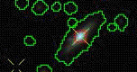
at the requested wide range of resolutions. One can overlay additional useful
information, including:
- boundaries of survey fields and aperture plates,
- outlines of individual objects and data quality masks, and
- locations of photometric and spectroscopic objects.
The tools can also search for lists of known objects, provide links for detailed
information, and formulate new database queries.
*Note: The Finding Chart, Navigate and Image Lists tools build mosaics on
the fly by overlapping SDSS
fields that may or may not belong to
different runs. The field area displayed
in the overlap region is determined by the (arbitrary) order in
which the fields are being superimposed by the mosaicing software. However,
the sky may have changed from one run to the next. Observations of moving or
variable objects like meteors, satellites, comets, variable stars, etc. may appear
in one run but not in the other, or be different from one run to the other. We
suggest that if you want to carefully examine any object(s) close to a field boundary,
you should use either the Get Image by
Field tool which displays the whole JPEG frame
for individual fields in each run, or get the FITS file from the
Explorer or the Science Archive Server. that may or may not belong to
different runs. The field area displayed
in the overlap region is determined by the (arbitrary) order in
which the fields are being superimposed by the mosaicing software. However,
the sky may have changed from one run to the next. Observations of moving or
variable objects like meteors, satellites, comets, variable stars, etc. may appear
in one run but not in the other, or be different from one run to the other. We
suggest that if you want to carefully examine any object(s) close to a field boundary,
you should use either the Get Image by
Field tool which displays the whole JPEG frame
for individual fields in each run, or get the FITS file from the
Explorer or the Science Archive Server.
|
- Finding Chart
The page returns a JPEG image centered on (ra,dec), of size (height x width) where
the image is scaled to an arbitrary scale (scale). Various drawing options can be
specified (opt). Please see Getting Started with Finding Chart.
- Navigate
This page provides easy navigation in the vicinity of a given point on the sky. One
can move around by clicking on the frame of the image, or on individual objects. A short
list of the basic properties and a magnified thumbnail image of the object nearest to
the selected point is then displayed. Please see Getting Started with Navigate.
- Image List
This page can generate thumbnails of SDSS images based upon a user defined
list of object positions. The images are linked to the other tools. The list can
also be specified with a query. Please see Getting Started with Image List.
- Quick Look
The Quick Look Tool contains basic data for an object - its position, magnitude, and redshift
- Explore
The Explore Tool contains a summary of an object, and interactive links to further detailed
properties, like its spectrum or neighbors, etc.
|